Gorakhpur to Kathmandu is roughly 377 km by road via Sonauli and Belahiya. The Nepal leg is 278.67 km in the Nepal Department of Roads distance calculator, while a Government of India road record describes Gorakhpur to Sonauli as about 98 km.
This guide uses Sonauli for the Indian border town and Belahiya for the Nepali post. Some Nepali official pages and the Department of Roads calculator spell the same Indian-side name Sunauli, so you may still see that variant in a source title or route dropdown.
It is also not the shortest way in. If your only goal is to reach Kathmandu by road, a different border is less than half the distance. Whether that makes it the better crossing is a separate question, and the answer is not a simple yes.
How far is Kathmandu from Gorakhpur?
The Nepal-side calculation is 278.67 km from the border node to Kalanki in Kathmandu. For the Indian leg, a Government of India road note says NH-29E, now NH-24, connects Gorakhpur to Sonauli via Pharenda and is about 98 km. A Google Maps route check supplied by the article owner on 23 August 2026 showed 95.4 to 98.1 km from Gorakhpur to Belahiya, depending on the alignment. Added together, these figures put the whole trip at roughly 377 km. The total remains a planning estimate because live routing can vary, while the 278.67 km Nepal figure is the exact result returned by the DOR calculator on the checked date.
| Leg | Distance | How solid the figure is |
|---|---|---|
| Gorakhpur to Sonauli and Belahiya | about 98 km | Government of India road note; owner-supplied map check showed 95.4 to 98.1 km |
| Sonauli and Belahiya to Kathmandu | 278.67 km | Nepal Department of Roads calculator. Exact result for the checked route |
| Total | roughly 377 km | Planning estimate; live map routing can vary |
The route check also displayed about 2 hours 20 minutes to 2 hours 23 minutes for the Indian leg before any border formalities. That is a live-map snapshot, not a promised travel time. The Sonauli to Gorakhpur road is national highway NH-24, previously numbered NH-29E, and it is being upgraded to four lanes under a programme announced by the Ministry of Road Transport and Highways in March 2023.
How long does Gorakhpur to Kathmandu take?
Allow about 11 to 14 hours by private car or taxi, and about 14 to 16 hours by through bus. These are planning ranges, not promised arrival times. Border processing, meal stops, traffic at Narayanghat and Mugling, roadworks and monsoon disruption can all extend the day.
The private-vehicle range starts with the owner-supplied route check, which displayed about 2 hours 20 minutes to 2 hours 23 minutes from Gorakhpur to Belahiya, plus a Nepal transfer operator's estimate of eight to ten hours from the border to Kathmandu. We widen the combined road time to 11 to 14 hours for a practical travel-day plan that includes normal stops and variable border processing. Nepal Tourism Board says a traveller entering in a private vehicle must carry an international carnet or complete customs formalities. It does not publish a standard processing time or a fixed road-tax amount, so neither is built into the estimate. The Gorakhpur district administration also confirms frequent road transport from Gorakhpur to Sonauli from early morning until late at night. None of these is an official timetable, which is why the answer remains a range.
Current through-bus schedules are slower but easier to plan around. A redBus operator listing showed an approximate 15 hour 15 minute schedule for one through coach when checked on 23 August 2026. Treat that as a planning signal, not a promise. Operators, departure times, fares and inventory can change.
| Option | Time to plan for | Price evidence | What the number means |
|---|---|---|---|
| Private car or taxi via Sonauli | about 11-14 hours | Quote required | Dated route check plus Nepal operator estimate, widened for routine stops and variable border processing |
| Through coach to Kathmandu | about 14-16 hours | Check the live fare | Current operator schedule as a planning signal; disruption can add hours |
| Train, then road | Your train to Gorakhpur, then the road time above | Depends on origin and date | There is no through train to Kathmandu |
| Flight from Gorakhpur | fastest connection found: 4 hours 40 minutes | from INR 12,248 in one live sample | One-stop itinerary, before check-in and airport transfers |
Bus, train, car or flight: what each option actually means
The through bus is the simplest low-cost option
A through coach avoids arranging a separate vehicle on each side of the border, but it is still a long road day. Depending on the departure, a coach may arrive during the day or overnight. Recheck the operator, boarding point, drop point, fare and luggage terms on your actual date because all five can change.
If you start in Delhi rather than Gorakhpur, the Delhi Transport Corporation's government-run Delhi-Kathmandu service is the cleanest official option we found. DTC publishes a fare of INR 2,800 for passengers aged five and above, a 10:00 IST departure from Dr Ambedkar Stadium Terminal, a one-hour check-in requirement, and a customs stop at Sonauli. Its page does not publish a dependable end-to-end duration, so confirm the operating day and expected arrival when booking.
Splitting the journey gives you more departures
The Gorakhpur district administration says buses for Sonauli run from about 03:00 until late at night. After crossing, continue from Bhairahawa or nearby bus points toward Kathmandu, Pokhara or Lumbini. This is more flexible than waiting for one through coach, but every transfer adds connection risk. Keep the full day free.
A train gets you to the border corridor, not to Kathmandu
There is no passenger railway from India to Kathmandu. Nepal Tourism Board's official road-entry table names Gorakhpur as the nearest Indian railway station for the Sonauli-Bhairahawa-Kathmandu route. In practice, "Gorakhpur to Kathmandu by train" means train to Gorakhpur, then bus, taxi or car for the border and the whole Nepal leg.
Raxaul is the corresponding railhead for Birgunj, and New Jalpaiguri serves the Kakarbhitta approach. The right railhead depends on which Indian city you start from and whether Kathmandu or Pokhara is your first destination.
Flying from Gorakhpur still requires a connection
Gorakhpur does not currently have a non-stop flight to Kathmandu. The Airports Authority of India lists Gorakhpur's direct destinations and Kathmandu is not among them. A live ixigo flight check on 23 August 2026 showed only one-stop itineraries, with the fastest at 4 hours 40 minutes and sampled fares from INR 12,248. Add check-in and transfers before comparing that with the road day.
Birgunj is shortest in the calculator, but the road choice matters
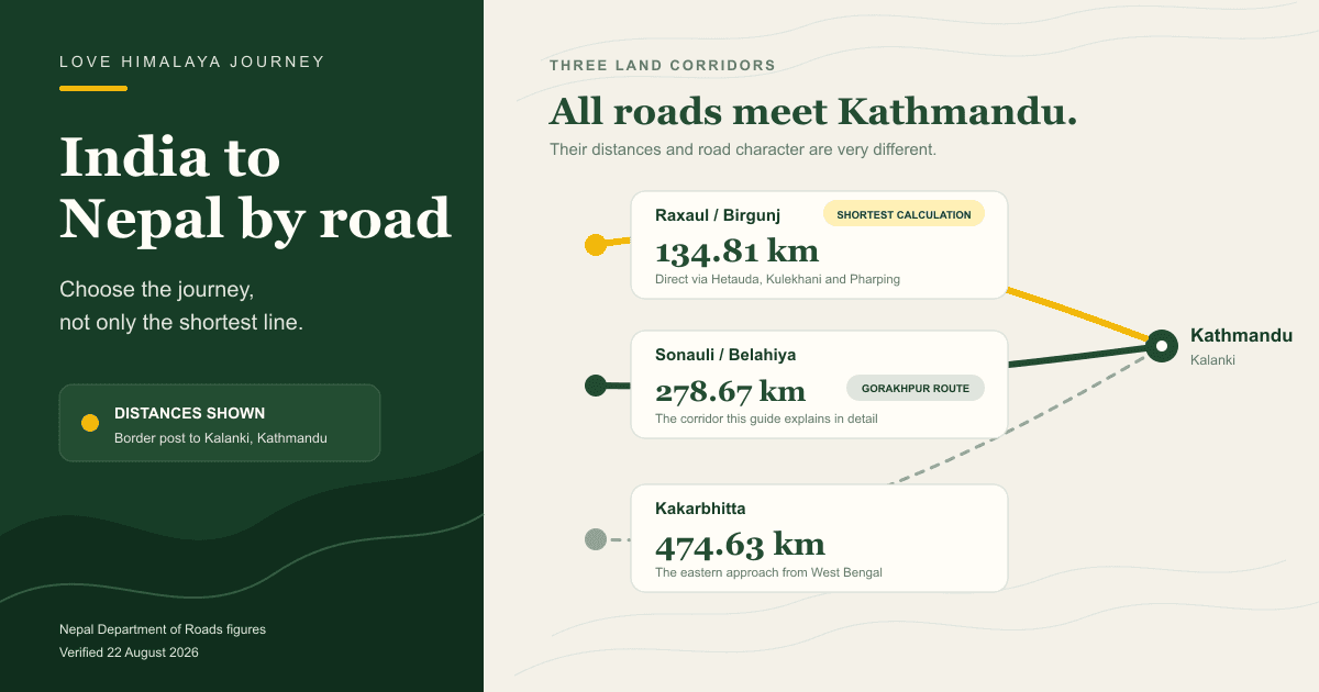
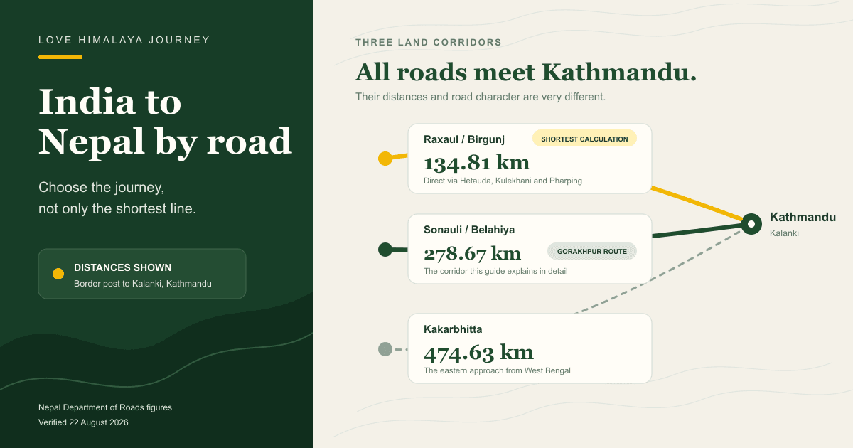
Raxaul and Birgunj is the shortest of the three calculations. The Department of Roads gives Birgunj to Kathmandu as 134.81 km, against 278.67 km from Sonauli and 474.63 km from Kakarbhitta. Its calculation runs through Pathlaiya, Hetauda, Bhainse, Bhimphedi, Kulekhani and Pharping. That is the direct short-road corridor from Hetauda, not the historic Tribhuvan Rajpath through Daman and Naubise.
This is the most useful thing on this page, and it is the part a distance figure on its own cannot tell you.
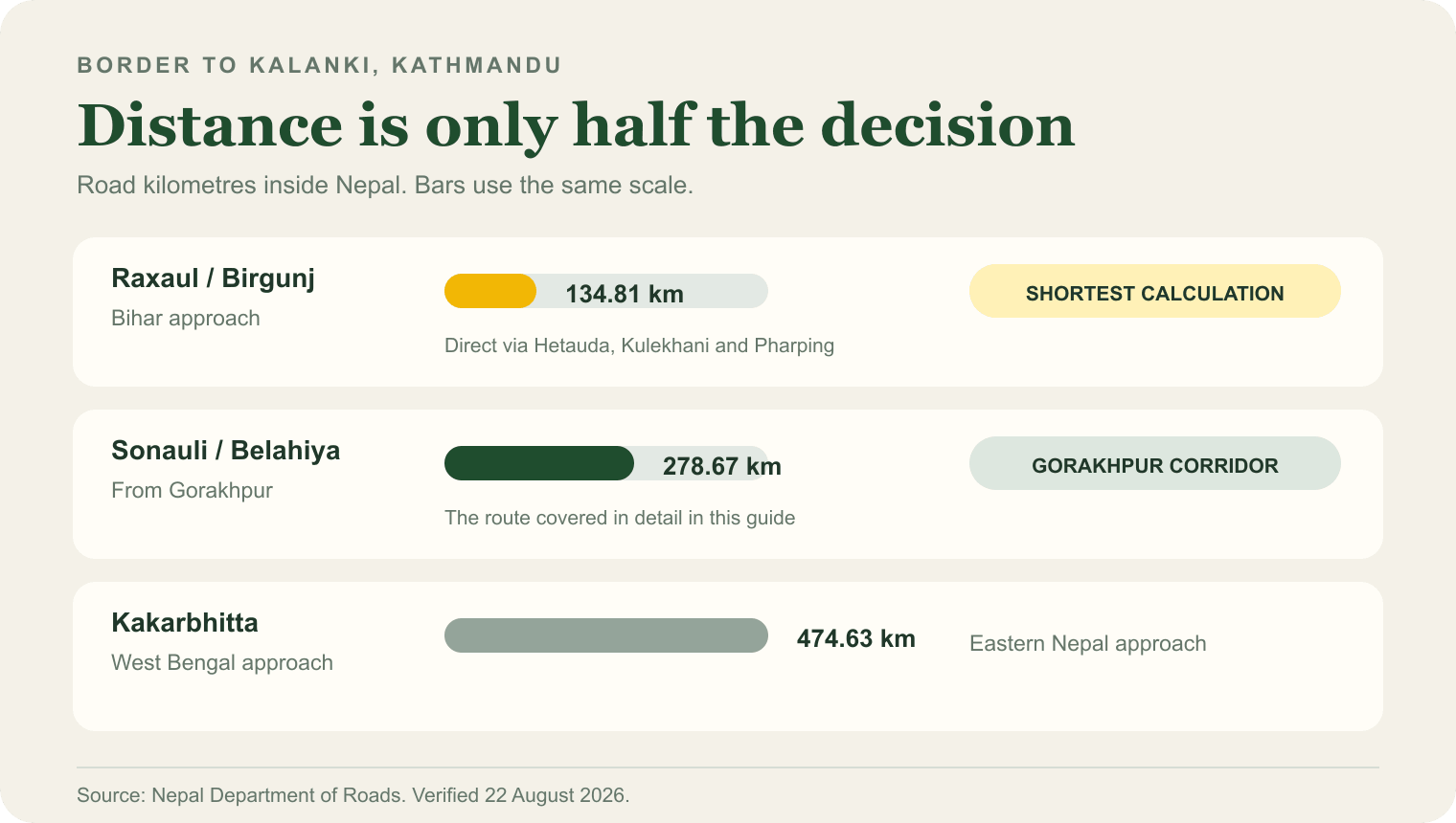
On distance alone Birgunj wins by 144 km. The Department of Roads strategic-road record identifies Pharping-Kulekhani and Bhimphedi-Kulekhani as separate feeder roads, and a Department of Roads feasibility notice describes the Kathmandu-Kulekhani-Hetauda connection as about 80 km. Those records are consistent with the calculator's direct Hetauda approach and show why calling it the Tribhuvan Rajpath was wrong.
The short hill roads are not a guaranteed coach route. They are narrower than the main highway and individual sections can close for construction or landslide repair, as happened on the Hetauda-Bhimphedi-Kulekhani-Phakhel-Pharping road after the September 2024 floods. From Hetauda, a vehicle can take a direct hill-road approach toward Kathmandu or make the much longer main-highway loop through Narayanghat and Mugling. The Narayanghat route may suit a large coach or a day when the short roads are unsuitable, but it is not the faster line.
Public schedules do not identify which alignment each coach uses. If the difference matters to you, ask the operator whether the bus uses Bhimphedi and Kulekhani or continues through Narayanghat and Mugling. Do not assume that a Birgunj ticket automatically means the 134.81 km calculation.
The route, segment by segment
The Department of Roads records the Sonauli to Kathmandu run through Bhairahawa, Butwal, Sunwal, Bardaghat, Narayanghat, Bharatpur, Mugling, Malekhu, Gajuri, Galchhi, Naubise and Thankot-Nagdhunga before reaching Kalanki.
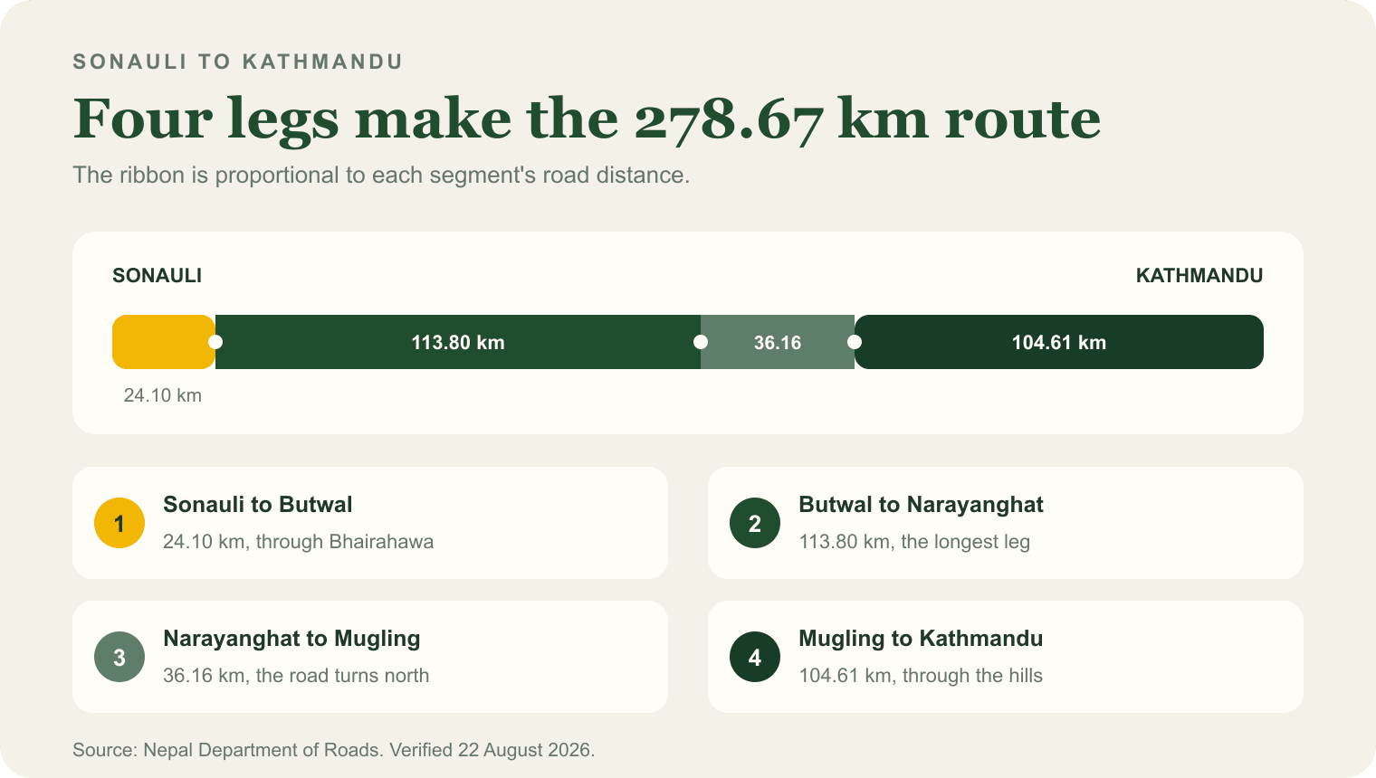
The shape of the journey matters more than the total. Roughly half the distance, the 113.80 km from Butwal to Narayanghat, is flat Terai running east. The road only turns north at Mugling, and the final 104.61 km into Kathmandu is the hill section. A trip that looks like a straight line on a small map is in fact a long eastward run followed by a climb.
Pokhara is a different road, not a stop on the way
No. From Butwal the roads split. Kathmandu lies east through Narayanghat and then north at Mugling, while Pokhara lies north on the Siddhartha Highway through Bartung and Syangja. Sonauli to Pokhara is 182.62 km, which is shorter than the run to Kathmandu, so Pokhara is a separate journey rather than a stop along the way.
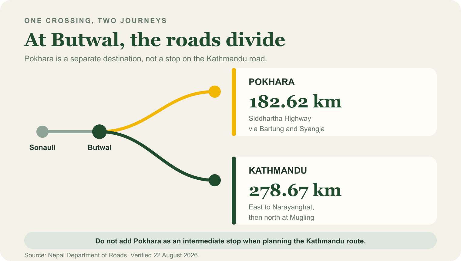
It is easy to assume Pokhara is somewhere you pass through, or a detour off the Kathmandu road. Neither is right from this direction. If Pokhara is where you are going, you leave the Kathmandu route at Butwal and take a shorter, separate highway. Planning it as a stopover adds distance rather than saving it.
If you are going to Lumbini
Lumbini is 27.91 km from the Sonauli border, through Bhairahawa. It is the closest major destination to that crossing by a wide margin.
For anyone crossing at Sonauli for Lumbini rather than for the mountains, this is the shortest onward leg of any destination we checked. India is also building a road from Kushinagar to Lumbini, announced in the same 2023 highway programme as the Sonauli four-laning and framed explicitly around Buddhist pilgrimage.
A new road is being built that will change this
The Nepal Army is building the Kathmandu-Terai/Madhesh Fast Track, an expressway running from Khokana on the southern edge of the Kathmandu valley down to Nijgadh in the Terai. Nijgadh sits on the Birgunj side of the country, which is why this matters for anyone weighing the crossings.
The project office states that the expressway "shortens the travelling distance from Kathmandu to Nijgadh by 193 km and saves travelling time by more than four hours". It is not open yet. When it is, the Raxaul and Birgunj approach becomes materially better rather than merely shorter on paper, and the comparison on this page will need revisiting.
We are not giving you an opening date. Large infrastructure timelines move, and a date quoted here would be the first thing on this page to go stale.
The other crossings
Raxaul and Birgunj is the shortest Department of Roads calculation to Kathmandu at 134.81 km through Hetauda, Bhimphedi, Kulekhani and Pharping, as discussed above. It is 258.92 km to Pokhara through Hetauda and Mugling. A Nepali government immigration office operates at Birgunj.
Kakarbhitta, in the far east, is 474.63 km to Kathmandu and 598.74 km to Pokhara, the length of the East-West Highway across the Terai. It makes sense if you are arriving from West Bengal or Sikkim and not otherwise.
Sonauli and Belahiya has its immigration office at Belahiya, in Bhairahawa.
| From | To Kathmandu | To Pokhara |
|---|---|---|
| Raxaul and Birgunj | 134.81 | 258.92 |
| Sonauli and Belahiya | 278.67 | 182.62 |
| Kakarbhitta | 474.63 | 598.74 |
Note what that table does to the Pokhara column. Sonauli is the closest crossing to Pokhara by a long way, while Birgunj is the closest to Kathmandu. There is no single best border; it depends entirely on where you are actually going.
What we have not covered here
Being straight about the edges of this article.
- The Indian approach to Raxaul and Kakarbhitta. We give the Indian leg for the Gorakhpur route only. The equivalent distances on the Indian side to Raxaul and to Kakarbhitta are not covered here, so the crossing comparison below is a comparison of the Nepali side of each journey, not of the whole trip from your starting city.
- A promised arrival time or fare. The time ranges and prices above are dated planning evidence. Check the live operator listing for your date before making a connection or budget decision.
- Border opening hours. The immigration office pages publish administrative office hours, which are not the same thing as when the crossing itself operates. We are confirming the real hours directly rather than repeat the office times and mislead someone who arrives at the weekend.
- Entry documents. Covered separately in our guide to what Indian citizens need to enter Nepal. In short: no visa, but the document you carry matters.
- Trekking permits. A separate layer again, covered in our guide to Nepal's trekking permits.
Where people go once they are across
The border is the logistics. These are the routes travellers ask us about most once they arrive.
- Everest Base Camp. Longer and higher than it looks in photographs.
- Annapurna Base Camp. Reached from Pokhara, which is the shorter side of the split at Butwal.
- Gokyo Lakes. The Everest region without the Base Camp crowds.
- Jomsom and Muktinath. For travellers who want the Himalaya and Muktinath in one trip.
- Langtang Valley. The closest serious valley to Kathmandu.
Getting to the border and across it is your part. Permits, lodging, guides and transport on the route are ours, and our displayed trek prices include the permit fees a route requires.
Sources
Road sources accessed 22 August 2026. Transport listings and official service pages checked 23 August 2026. External links open in a new tab.
Road distances
- Nepal Department of Roads - Distance Calculator. Every Nepal-side distance and route on this page. The tool returns a node-by-node route as well as a total.
Indian highway records
- Press Information Bureau, India - Gorakhpur to Sonauli via Pharenda. Describes the NH-29E connection as about 98 km.
- Ministry of Road Transport and Highways, India - NH-24/NH-29E Sonauli-Gorakhpur. The Sonauli to Gorakhpur section, its highway numbering and chainage.
- Press Information Bureau, India - 18 national highway projects in Gorakhpur, 13 March 2023. The March 2023 announcement of the Sonauli to Gorakhpur four-laning and the Kushinagar to Lumbini road.
Road conditions and new construction
- Nepal Department of Roads - Strategic Road Network annex. Identifies Pharping-Kulekhani and Bhimphedi-Kulekhani as feeder roads.
- Nepal Department of Roads - tunnel-road feasibility notice. Describes the Kathmandu-Kulekhani-Hetauda connection as about 80 km.
- The Kathmandu Post - Hetauda-Kathmandu short route to reopen after landslide repairs, 6 October 2024. Identifies the Hetauda-Bhimphedi-Kulekhani-Phakhel-Pharping short route and documents disruption after the September 2024 floods.
- Nepal Army - Kathmandu-Terai/Madhesh Fast Track project. The Kathmandu-Terai/Madhesh Fast Track and its stated effect on the distance and time between Kathmandu and Nijgadh.
Border offices
- Immigration Office Belahiya. The immigration office on the Nepali side of the Sonauli crossing.
- Immigration Office Birgunj. The immigration office at Birgunj.
Times and transport modes
- Gorakhpur district administration - Tourism. Frequent buses from Gorakhpur to Sonauli from early morning until late at night.
- Nepal Tourism Board - Travelling by road and entry points. Designated crossings, approximate border-to-city distances and the nearest Indian railhead for each route.
- Delhi Transport Corporation - Delhi-Kathmandu Bus Service. Published fare, departure point and time, check-in rule and Sonauli customs stop.
- redBus - Gajraj service. Approximate through-coach schedule checked 23 August 2026; no sampled fare is published in this article.
- Airports Authority of India - Gorakhpur Airport FAQ. Current direct destinations from Gorakhpur.
- ixigo - Gorakhpur to Kathmandu flights. Dated connecting-flight time and fare snapshot.
- Nepal Vehicle Hiring - Kathmandu to Sonauli. Operator planning range for the Nepal road leg, used as an estimate rather than an official time.
Sources we did not use
We excluded distance-aggregator pages and travel forums from the route geometry. Ticket platforms appear only for dated, live schedule and fare snapshots; none of their distance figures is used. One figure we encountered while researching this article put Kathmandu to Butwal at 588.67 km. That cannot be right: the Department of Roads gives 278.67 km for the longer Sonauli to Kathmandu run, and a shorter leg cannot exceed a longer one. It appears to describe routing the long way around on the East-West Highway. We rejected it.
We also want to be plain about a subtler failure mode, because we nearly published it ourselves. A distance figure can be correct and still mislead if it does not say which road it follows. The Birgunj number is the clearest case: right to two decimal places, and incomplete without the alignment. A number without its road is not an answer, which is why the section above spends more words on the road than on the figure.
What can change after publication
- Road distances, if alignments change. The Sonauli to Gorakhpur section is under upgrade. Last checked 22 August 2026.
- The Indian leg figure, which we expect to firm up once a highway document can be read directly.
- Border office contact details and hours.
- Bus schedules, fares and connecting-flight options. Recheck before every meaningful update and never convert a dated snapshot into a standing promise.
- The Kathmandu-Terai/Madhesh Fast Track. When it opens, the Raxaul and Birgunj comparison on this page changes materially and this article will need rewriting rather than patching.
Corrections
If any figure here becomes wrong, we will correct it on this page and date the correction. If a road authority publishes a different number, tell us and we will check it against the source.
Frequently asked questions
How far is Kathmandu from Gorakhpur?
Gorakhpur to Kathmandu is roughly 377 km by road via Sonauli and Belahiya. A Government of India road note describes Gorakhpur to Sonauli as about 98 km, and the Nepal Department of Roads calculator gives 278.67 km from the border node to Kalanki in Kathmandu. The total is a planning estimate because live routing can vary.
Which India to Nepal border crossing is closest to Kathmandu?
Raxaul and Birgunj is the shortest of the three calculations. The Department of Roads gives Birgunj to Kathmandu as 134.81 km, against 278.67 km from Sonauli and 474.63 km from Kakarbhitta. Its calculation runs through Pathlaiya, Hetauda, Bhainse, Bhimphedi, Kulekhani and Pharping. That is the direct short-road corridor from Hetauda, not the historic Tribhuvan Rajpath through Daman and Naubise.
Is Pokhara on the way to Kathmandu from the Indian border?
No. From Butwal the roads split. Kathmandu lies east through Narayanghat and then north at Mugling, while Pokhara lies north on the Siddhartha Highway through Bartung and Syangja. Sonauli to Pokhara is 182.62 km, which is shorter than the run to Kathmandu, so Pokhara is a separate journey rather than a stop along the way.
How far is Lumbini from the Indian border?
Lumbini is 27.91 km from the Sonauli border, through Bhairahawa. It is the closest major destination to that crossing by a wide margin.
How long does Gorakhpur to Kathmandu take?
Allow about 11 to 14 hours by private car or taxi, and about 14 to 16 hours by through bus. These are planning ranges, not promised arrival times. Border processing, meal stops, traffic at Narayanghat and Mugling, roadworks and monsoon disruption can all extend the day.
Can you travel from Gorakhpur to Kathmandu by train?
There is no passenger railway from India to Kathmandu. Nepal Tourism Board's official road-entry table names Gorakhpur as the nearest Indian railway station for the Sonauli-Bhairahawa-Kathmandu route.
Something here out of date or wrong? Tell us and we will check it.